Double Trouble: Storms Konrad and Another on the Horizon
Portugal is set to face not one, but two storms in just two days. After barely recovering from the impact of Storm Jana, the country is bracing for a frontal system associated with Storm Konrad on Wednesday and a yet unnamed depression on Thursday. These storms are expected to bring heavy rain, thunderstorms, hail, snow, strong winds, and rough seas.
This unstable weather pattern is likely to take a brief pause only on Friday and possibly Saturday, but instability will persist into next week, with constant shifts expected until at least the beginning of Spring, which officially starts on March 20 at 9:01 AM.
What to Expect
- Storm Konrad, the 11th storm of the season, will remain stationary north of the Azores and has already impacted the islands on Tuesday. The first effects will be felt in Madeira early Wednesday morning, with warnings for rain and wind (yellow alert) and sea agitation (orange alert).
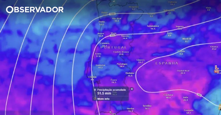
- As the storm reaches the mainland on Wednesday morning, expect another day of heavy rain, particularly in central and southern Portugal, with potential flooding in some areas. Snow is forecasted for the districts of Castelo Branco and Guarda, with altitudes potentially dropping to 800-1000 meters.
- On Thursday, the storm will hit the southern mainland in the early morning, bringing heavy rain and thunderstorms, with wind gusts of up to 60 km/h in the Algarve and waves of 4-5 meters. Yellow alerts have already been issued for heavy rain in Faro, Beja, Évora, and Setúbal.
- Heavy snow is also expected in the higher elevations of Serra da Estrela.
A Clash of Air Masses
The upcoming weather is due to a clash of air masses. While southern Europe, including Greece, Romania, and Turkey, experiences temperatures reaching up to 30°C from warm air, Portugal, Spain, and France might struggle to hit 10°C, facing heavy snowfall instead.
From March 13 to at least March 17, the Iberian Peninsula will experience a period of low temperatures as winter makes a brief return. This clash is responsible for intense rainfall, more powerful thunderstorms, and the potential for hail.
Looking Ahead
Rain is expected to return over the weekend, as the train of storms continues until at least the start of Spring next week. Following this Wednesday and Thursday's storms, another powerful system is forecasted to arrive by Sunday.


Comments
Join Our Community
Sign up to share your thoughts, engage with others, and become part of our growing community.
No comments yet
Be the first to share your thoughts and start the conversation!