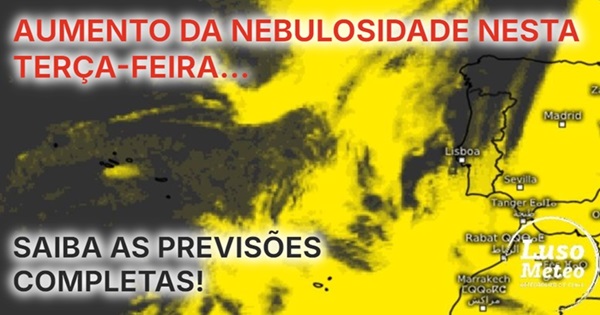
Weather on Tuesday, February 4, 2025
The weather forecast for Tuesday, February 4, indicates a significant increase in cloud cover across the country, especially in the North and Central regions and along the coast. This is due to the approach of a frontal system, which, according to all weather models, is expected to dissipate before reaching our territory.
This means that precipitation is unlikely, with only overcast skies potentially blocking the sun, particularly in the afternoon after a day of clear skies on Monday. Expect another cold night with frost formation in several areas, though minimum temperatures may only drop slightly. With the days becoming longer, maximum temperatures will begin to rise when sunny, allowing homes to warm up a bit more.
Take advantage of the sun now, as it may soon become scarce. The MetOffice forecast shows the approaching frontal system trapped between the Central European anticyclone and the Azores anticyclone, leading to its expected dissipation.
Weather Conditions in Different Regions
Azores
In the Azores, forecasts suggest that the weather will become unstable in the afternoon, with a likelihood of showers and thunderstorms, as well as increased winds generally from the east or southeast.
Madeira
For Madeira, the same frontal system affecting mainland Portugal is also approaching but will dissipate, resulting in increased cloudiness with minimal precipitation.
Detailed Forecast
- Mainland Portugal: Generally partly cloudy, quickly becoming overcast from the coast to the interior, especially with high clouds, with some sunny intervals, particularly in the central and southern regions.
- Temperature: Little significant change expected, possibly a slight drop in minimums and a slight rise in maximums.
- Winds: Generally light winds blowing from the east at 10-20 km/h.
- Sea Conditions: Slightly rough seas with waves up to 3-4 meters off the western coast, especially north of Cabo Carvoeiro, and up to 3 meters further south.
- Water Temperature: Expected to remain between 14-16°C on the western coast and 16-17°C on the southern Algarve coast.
Upcoming Changes
Despite the stable weather expected until the end of the week, changes are anticipated, possibly starting Friday with some rain. The following weeks may present chaotic weather patterns, especially considering the unusual predictions for a sudden stratospheric warming affecting the polar vortex, which could significantly alter weather patterns across Europe, including Portugal.
Stay tuned for updates as this situation develops, and let us know your thoughts in the comments below: Do you believe these changes will happen, or will February maintain its stability? Join the conversation!


Comments
Join Our Community
Sign up to share your thoughts, engage with others, and become part of our growing community.
No comments yet
Be the first to share your thoughts and start the conversation!